

A short history of flooding in Lismore
Lismore was first settled by red cedar cutters and farmers looking for high quality fertile land. All transport was by boat, using the river system as a major trade route to the sea.
Ships could not travel upstream much further 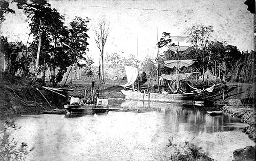 than the junction of Leycester Creek and the Wilsons River. This junction was also suitable for the ships to turn around.
Lismore grew rapidly around the river trade, timber and agricultural industries, becoming one of the major North Coast towns. In the 1890s the railway linked the river and rail systems, further confirming Lismore’s status as a regional centre.
The importance of the river diminished as road transport improved after WWII. By this time Lismore was a major city, established adjacent to the Wilsons River.
While the location of Lismore is ideal as a service and trading centre for produce and freight, floods come very quickly and consequently have a major impact.
During heavy rain, rainfall from the high surrounding hills comes down the steep creeks and rivers meeting at Lismore, then slowing down and spreading across the floodplain before moving out to sea.
In 1954 and 1974 Lismore experienced very severe flooding, creating major problems for the community.
Following the 1974 flood, the government of the day commissioned a number of studies to consider ways to overcome Lismore’s flood problems.
The then government assisted with the purchase of land at Goonellabah to create a new commercial area and new planning schemes to limit growth in floodplain zones. A voluntary purchase scheme aimed at assisting people to move out of the seriously affected flood zones was also introduced. The study concluded by stating that it would be very difficult to construct a levee system for Lismore.
Following the 1989 flood the concept of a levee to protect the CBD was again investigated. After examining the hydraulic effects of more than 20 possible levee schemes, it became clear that it was both practical and financially feasible to construct a limited levee system around South and Central Lismore.
In 1999 a government-funded scheme to protect the CBD and South Lismore from a 1-in-10-year flood event was approved. This proposal would mean that most of the smaller floods would not enter the central area of Lismore and substantially improve the time available for the evacuation of residents and the business community in larger floods.
SOURCE https://www.lismore.nsw.gov.au/cp_themes/default/page.asp?p=DOC-DYM-80-74-5
| LINK Lismore Floods: Wilsons River Flood Heights and Lismore Flood Pictures ... Richmond River Catchment Northeast NSW Report and all photos by Michael Bath Facebook page: www.facebook.com/nnswweather LINK Curious North Coast: Why was Lismore built on a floodplain?NEWS Flood timeline as it happened Tuesday, March 28: 20172.28pm: BoM issue Flood Watch for Moderate to Major flooding for the Tweed, Brunswick, Richmond-Wilsons, Clarence and Upper Macintyre Valleys.3.00pm: Flood Watch issued by the SES. Wednesday, March 29: Ex-Tropical Cyclone Debbie moves into Northern NSW. 9.57am: BoM issue Severe Weather Warning for Heavy rainfall. 10.45am: SES issue Severe Weather Warning. Thursday, March 30: 9am: SES issue a Flood Watch for the "Richmond-Wilsons River Valley” and others. 12noon: SES re-issue a warning titled: "Severe Weather Warning and Flood Watch issued for people in the Northern Rivers” 12.39pm: BoM issue Moderate Flood Warning. 1.52pm: River at Nimbin passed its 1974 level according to the Lismore Citizens' 2017 Flood Review. 3.38pm: BoM issue Major Flood Warning for 11m early Friday morning. 4pm: SES issue Major Flood Warning for the Wilsons River. SES also issue Moderate to Major Flood Warning for the Tweed River. 4.30pm: SES again issue Major Flood Warning for the Wilsons River Flood Evacuation Order for Lismore CBD, and North and South Lismore As a result of a revised prediction by the Bureau of Meteorology for the Wilson River at Lismore of 11 metres early Friday morning, the NSW State Emergency Service is directing residents to evacuate immediately. Do not delay your evacuation. Roads will be congested or closed. You could become trapped and need rescue. Remaining in flooded areas is dangerous and may place your life at risk. 8.15pm: Major Flood Warning issued for the Wilsons River at Lismore and minor to moderate flood warning for the Richmond River. People in low lying areas in Lismore CBD, North Lismore and South Lismore should evacuate immediately to family and friends outside of the flood zone. An Evacuation Centre has been set up at Southern Cross University - Military Road East Lismore. 9.44pm: BoM issue warning of 11.5m height on Friday morning. SES issue Major Flood Warning issued for the Wilsons River at Lismore and minor to moderate flood warning for the Richmond River Authorised By: Andrew McPhee (Incident Controller) People in low lying areas in Lismore CBD, North Lismore and South Lismore should evacuate immediately to family and friends outside of the flood zone. An Evacuation Centre has been set up at Southern Cross University - Military Road East Lismore Major flooding is forecast along the Wilsons River at Lismore Thursday night, with river levels predicted to be higher than the 2001 and 2005 floods. Further rises are possible with rainfall forecast overnight tonight. 10pm: Flood Evacuation Warning for Kyogle Residents should monitor the situation and be prepared to evacuate when instructed to do so. A Flood Evacuation Order will be issued by the NSW SES if evacuation is required. 11.30pm: Flood Evacuation Order for Lismore CBD, and North and South Lismore As a result of a revised prediction by the Bureau of Meteorology for the Wilson River at Lismore of 11.5 metres on Friday morning, the NSW State Emergency Service is directing residents and businesses are to evacuate immediately. The levee may commence to overtop into the CBD anytime from midnight tonight. When the levee begins to overtop, a siren will be sounded. This will be: Siren for One Minute, Silence for One Minute, and Siren again for one minute. When you hear this siren, you must evacuate the CBD immediately as evacuation routes will be congested and close quickly. Friday, March 31: Levee breached. BoM lists a 3am levee breaching time. 11.12am: Flood peak 11.59m. |
No comments:
Post a Comment